


All Persons Trail Geology
The Mary Mallarkey all Persons Trail is located on the edge of the White Mountains, an area dramatically affected by the last glacier, known as the Wisconsin Ice Sheet. The following essay of glacial geology is a collaboration of two noted geologists: Dr, Richard Allendinger and Dr. Robert Newton. It paints a wider picture of the region where the trail is located, as well as the small area of the trail itself. Both geologists were delighted to join their knowledge, another example of community involvement that the trail represents. Also, for visual appreciation, below is a DEM, a Digital Elevation Model of the trail and nearby features created by Dr. Newton, and another DEM oblique view of the trail created by Dr. Allmendinger.
25,000 years ago, the great Laurentide ice sheet covered all of New Hampshire to a depth of thousands of feet and reached as far south as Cape Cod and Long Island. By 14,500 years ago, however, the ice sheet was dying thanks to natural climate change driven by variations in solar irradiation. As the ice sheet thinned in this region, the emerging White Mountains formed a barrier to the southeast flowing continental glacier, forcing ice to flow around the emerging mountains. This split the glacier in this area, into two lobes; one lobe was located between the Sandwich Range to the north and the Ossipee Mountains to the south. Here, ice was flowing eastward and even northeastward up the back side of Whiteface Mountain. The second lobe was located east of Mt Chocorua with ice flowing southward from the Saco Valley in Conway toward Ossipee. The boundary between these two lobes is marked by the Swift River Valley near Tamworth village.
As the ice thinned due to melting, it eventually stopped flowing forward and simply melted in place. The melting of thousands of feet of glacial ice created tremendous volumes of meltwater that flowed through this area of stagnant ice. Streams running underneath and over the top of the ice deposited sinuous accumulations of gravel that we call eskers. If you look to your right (west), about 200 ft from the trailhead, you can see the blunt nose terminus of the Heron Pond esker, and the steep slopes behind the parking area crossed by the Hammond trail are also eskers. Heron Pond Is a kettlehole, the topographic depression left by a melting block of stagnant ice after most of the rest of the ice melted away. The meltwater deposited lots of sand and gravel both at the margins of the ice, called kame terraces, and just beyond the ice, known as outwash plains. Many of the flat kame terraces are pockmarked, evidence of the former presence of smaller blocks of ice surrounded and covered by the gravel deposits which today form the uppermost reaches of the Ossipee Aquifer. Some of this meltwater flowed westward, spilling across the divide between the Chocorua River and Swift River emptying into the gap between the two retreating ice lobes.
The trail itself is located on younger accumulations of sand and gravel deposited as part of the Stony Brook alluvial fan. These are modern post glacial stream deposits which form below steep mountain slopes. The entire trail is located on this feature with Stony Brook currently running just to the east of the trail. At the platform at the end of the trail, a serene view of the modern Chocorua River awaits you. The river formerly occupied a channel 500 to 800 ft farther to the east where Scott Road leaves Rt. 16 but with time has migrated gradually westward to its current position.
Bob Newton, professor emeritus at Smith College is a hydrologist and geomorphologist interested in the interaction between landscapes, water and chemistry and unraveling landscape history using high-resolution light detection and ranging (LiDAR) data for imaging geomorphic features and processes. He leads other geologists on field trips to the White Mountains, gives talks on the geology of the Ossipee Range, and has updated and worked on New Hampshire Geological Survey maps.
Rick Allmendinger is Professor Emeritus of Earth and Atmospheric Sciences at Cornell University. He is by training a structural geologist and has spent most of his career working in the Andes and the western United States. Nonetheless, he is a New Hampshire native by birth who now lives in the state full time, and his family have owned property in the Chocorua Lake Basin for nearly 100 years.
.jpg)
.jpg)

The Mary Mullarkey All Persons Trail ribbon-cutting was held on July 16, 2026. You can read the story from the July 18, 2026 Conway Daily Sun by clicking here.
Ribbon-Cutting Ceremony

Final Update on Mary Mullarkey All Persons Trail
The Mary Mullarkey All Persons Trail is complete!
Construction wrapped up on October 16, 2025, as Matt Coughlan and his team from Recon Trail Designs put the finishing touches on the boardwalks and kiosk. The trail is truly a work of art, and the workmanship reflects the experience and expertise, as well as the attention to detail that Matt and his team demonstrated throughout this project. Many thanks Matt!
The last piece of this project will be the installation of interpretive signs along the trail. These signs will serve to educate visitors about the different trees, flowers, and critters that inhabit the area. They may also identify other features of the woodland area surrounding the trail. It could be a wonderful opportunity for local craftsmen to share their talent in helping TCNA design and build these simple yet useful additions to the trail.
The trail will not be maintained during the winter months, but we will be checking periodically, especially after storms, for any damage that may occur. In the spring, a formal ‘ribbon cutting and formal opening ceremony’ is in the works, date TBD.
A sincere “THANK YOU” to all who contributed to this project. From the TCNA board members and others who could envision an All Persons Trail winding through the trees six years ago; the contractors, Bruce Robinson Company, for the parking lot, and Recon Trail Designs, for the construction; the foundations and organizations who provided significant funding through grant awards; and for all of the private donations that were received that helped bring this project to fruition. The Mary Mullarkey All Persons Trail is a treasure that we hope residents and visitors will use and enjoy for generations to come!
Donations to the trail are always welcomed as they will help with the cost of future maintenance to preserve the boardwalks and platform or repair any damage that may occur to these sections.


September 29, 2025 Update
Heading into the home stretch!
-
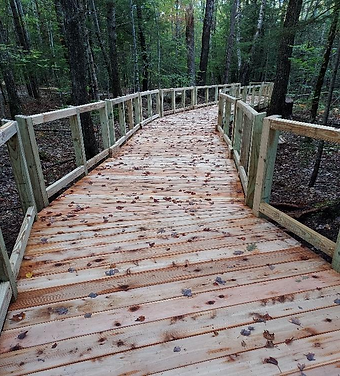
The long boardwalk section is nearly complete. The Recon Trail Design crew is working on screening and finish work on the railings.
-
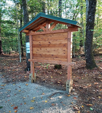
The kiosk is built and in place at the beginning of the trail.
-
The resting benches are next to be built and installed on the trail and viewing platform.

September 17, 2025 Update
-
It’s been a few weeks since the last update, and WOW! A lot has been accomplished on the trail construction.
-
The 250’ section of boardwalk is in the decking stage.
-
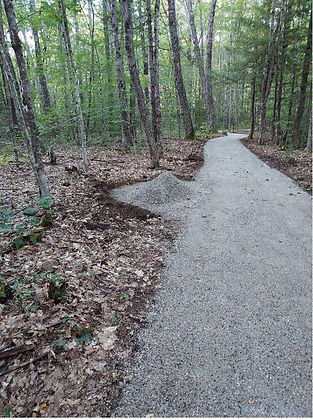
The 600’ stone dust section of the trail has been put down, with a bump-out for a resting bench.
-
The area for the placement of the kiosk has been prepared.
-
The 75’ boardwalk section is nearly complete, as is the viewing platform.
-
The 150’ stone dust section is complete.
-
Check out the latest photos, or better yet, take a ride down to Scott Road and check it out in person. You won’t be disappointed!



August 17, 2025 Update
-
Work on the viewing platform continues, with decking and railing installation started. It will be a beautiful place to go to and listen to the Chocorua River as it flows by.
-
The 75’ boardwalk section leading to the viewing platform is framed. The approximate 150’ stone dust section of the trail leading to the boardwalk is in place.
-
Work on the 250’ boardwalk section will be next. The trail is being constructed from the end and working back to the beginning. Along the way, the trail is being worked, rocks and swales added to direct water away from the trail. The photo below shows the sections of the trail, so you can have a better idea of where work is happening. The loop (Segment C) is not part of this project.

Check out the progress below by clicking on the photos.


August 3, 2025 Update
-
Work on the trail corridor continued, with excavation of sod layer along sections closest to the viewing platform, followed by placement of geotextile material on excavated surfaces. Crushed gravel is placed on geotextile material, stone dust mix is placed on gravel, making up the surface of the trail corridor.
-
Helical piers for the boardwalk leading to the viewing platform were installed.
-
Helical piers for the viewing platform were installed.
-
Framing for the viewing platform began.
Check out the progress below by clicking on the photos.


July 30, 2025 Update
-
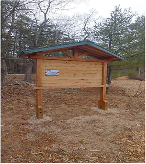
Thank you to the Tamworth Outing Club for sponsoring the construction of the kiosk that will be located at the beginning of the trail. The kiosk as well as the resting benches along the trail and on the viewing platform will be built by Recon Trail Design from Parsonsfield, ME.
-
Trail construction began on July 21, 2025. The Recon Trail Design team moved equipment and materials to the site and started cutting in the trail corridor.
-
Staking for the helical piers for the viewing platform was completed.
The amount of progress in one week is amazing, and the trail is coming to life!
Check out Week 1 pics below by clicking on the photos.


June 27, 2025 Update
The parking area on Scott Road that will accommodate parking for the trail has been enlarged and improved, and it is beautiful! Thank you to Bruce Robinson Company for the amazing job they did to transform the lot from the wooded and rooted ‘park between the trees’ area to the 64’x 80’ cleared and compacted parking lot, finished with wood chips around the entire perimeter. For anyone who is familiar with the parking area for the Hammond Trail to Mt. Chocorua, wait until you see it now!

Before

After

.jpeg)


Tamworth Community Nurse Association (TCNA), in collaboration with the Chocorua Lake Conservancy (CLC), is excited to announce the planned construction of the first All Persons Accessible Trail in Tamworth.
The ADA-compliant trail will be located on conservation land owned by the Korson family and will be known as the Mary Mullarkey All Persons Trail in honor of Tom Korson's late wife and Andrew Korson's mother. Mary Mullarkey passed away in 2021, after many years living with multiple sclerosis. Throughout her distinguished career, she served as a Supreme Court Justice in Colorado for 23 years—12 of which were spent as the state's first female chief justice—prior to her retirement in 2010.
The trail will be accessible from the Hammond trailhead parking area on Scott Road in Tamworth. It will feature a picturesque woodland setting, a seasonal brook, and culminate at a viewing platform on the bank of the Chocorua River, equipped with railings and a bench for visitors to rest and enjoy the natural surroundings. The trail spans 0.5 miles round trip and will include compacted stone dust mix and boardwalk sections with railings over wet areas. Additionally, interpretive signs will highlight special features along the trail, serving as educational tools. A welcoming kiosk at the trail's entrance will provide visitors with information about the trail and acknowledge the foundations, organizations, and individual donors who contributed to making this vision a reality.
The planning for this project began nearly five years ago, inspired by a former TCNA board member who recognized the need for a local accessible trail during a visit from her son. Accessible trails suitable for individuals with mobility issues are limited in the surrounding area; there are none in Tamworth. The first meeting was attended by community members who gathered to talk about ideas and possible locations for an accessible trail in Tamworth. Subsequent meetings and potential site visits were attended by members of TCNA, CLC and the Tamworth Conservation Commission. Many locations were evaluated before the group found what they felt was the ideal location on Scott Road. Following that initial site visit, Sheldon Perry went down to Scott Road and walked out along Stony Brook to the Chocorua River, mapping out the proposed trail route and observing the contours of the ground he was walking using the Chocorua Map app on his phone that was developed by Rick Allmendinger. The site was reasonably level with a couple of wet areas and offered a flowing stream, a beautiful and quiet forest setting, and a destination point on the Chocorua River. The Korson family was presented with the idea of an All Persons Trail on their property, which they graciously approved.
Since then, ongoing meetings, workshops, and grant writing efforts have been conducted. CLC members have collaborated closely with us to ensure adherence to restrictive covenants and have committed to assisting with oversight and routine maintenance of the trail. The Tamworth Conservation Commission has supported us in securing necessary permits for the project. Additionally, we have received backing from the Tamworth Outing Club, the Tamworth Selectboard, and the Carroll County Coalition for Public Health. Financial support has been provided through grants from the NH Bureau of Trails Recreational Trail Project Program, Fields Pond Foundation, The Tamworth Foundation, and the NH Charitable Foundation. These competitive grants reflect the project's merit and worthiness of support.
Matt Coughlan from Recon Trail Design, LLC in Parsonsfield, ME, is the talented trail builder for this project. He has crafted the boardwalk and observation deck at the Alice Bemis Thompson Wildlife Sanctuary and the accessible trail at Tin Mountain Conservation Center. Trail clearing began on March 3, and construction is scheduled for late summer/early fall. By November, we hope to have a beautiful All Persons Accessible Trail for everyone to enjoy.
To accommodate accessible parking for the trail, this project also includes expanding the Hammond trailhead parking area from its current capacity of 3-4 vehicles to12 vehicles, with designated accessible parking spaces.
TCNA views this All Persons Accessible Trail as an extension of the health services we provide, using the natural environment to promote improved health and wellbeing of residents and visitors. From the youngest to our most senior citizens, all can enjoy the experience of being out in the woods, the sounds, the smells, the sights that draw us in, bring us peace, allow us to escape the busyness of the day, if just for a few minutes. Children can explore while walking along a flat, safe surface or enjoy riding along in a stroller; adults can gather to socialize and catch up with friends. The possibilities are endless!
If you would like more information about this worthwhile project, please email teresamf60@gmail.com.
Thank you for reading!